Rapid Response, Monmouth County, NJ
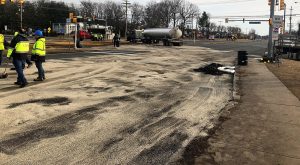 A petroleum tanker truck was involved in an accident with another tanker truck at a major intersection in Monmouth County, New Jersey. Both tanker trucks lost product and the total released volume was approximately 3,500 gallons of diesel and approximately 2,500 gallons of gasoline. The petroleum released from the trucks to the asphalt road surface and flowed overland along Route 9 in the northern direction. The release reportedly entered two inlets to the storm sewer system north of the accident location and was discharged to a tributary of a surface water body and associated wetlands, approximately 1,000 feet north of the accident location. Immediately following the petroleum spill, the first responders and a remediation contractor emptied the two tanker trucks of residual petroleum, deployed oil absorbent materials to the road surface and around the storm water inlets, utilized vacuum trucks to remove petroleum form the surface water body, and deployed oil absorbent materials on the Deep Run tributary and associated wetlands to limit further migration of the petroleum and to protect the receptors. Following the release, petroleum was observed at one of the storm water sewer system inlets located approximately 300 feet north of the accident location and the corresponding storm water sewer outfall located approximately 1,000 feet north of the accident location. Additionally, the release was observed 500 feet downstream of the outfall, and within the wetlands, located along the first 500 feet of the Deep Run tributary, downstream of the outfall. Subsequent mitigation efforts within the wetlands included biweekly replacement of the oil absorbent materials and monitoring.
At the time of the accident, the released petroleum mixture traveled down the asphalt-covered highway to an unpaved highway median. The release pooled around one of the storm drains, the contractor deployed oil absorbent materials on the ground surface and near the storm drains. Peak directed and oversaw excavation of soils within the highway median and post-excavation soil samples were collected and analyzed by a laboratory, which indicated no contaminants of concern exceeding applicable NJDEP standards. The excavation was backfilled with certified clean fill and no further action was required.
Peak secured access to eight potentially impacted properties to perform the initial SI of the wetlands to assess impacts associated with the spill. The wetlands span across multiple off-site properties, and areas of impact were identified visually and with field instruments, and further investigation ensued where needed. Peak collected a total of 202 soil samples from the off-site properties. The results of the remedial investigations indicated multiple contaminants of concern detected at concentrations greater than applicable NJDEP standards and/or screening criteria at 15 locations. Impacted locations were delineated to applicable NJDEP standards and remedial action is proceeding.
Peak also collected three surface water samples to assess the quality of the surface water body traversing the wetlands. Surface water samples of the tributary did not indicate compounds concentrations greater than applicable standards.
The groundwater investigation at the accident location is not required based the expedited remediation (1 day after) of soil and the shallow depth of the remediation. The groundwater investigation at the off-site properties has not been completed, however; a groundwater investigation is proposed pending NJDEP approval of the Land Use Permits. The groundwater investigation proposal includes installing two temporary or permanent monitoring points in the impacted wetland area and downgradient of the identified impacts.
Petroleum-related contaminants are present in soil within an environmentally sensitive natural resource (ESNR), identified as wetland area, at concentrations greater than NJDEP Ecological Screening Criteria, default Impact to Groundwater Soil Screening Levels (dIGW SSL), Residential Direct Contact Soil Remediation Standard (RDC SRS) and Soil Saturation Limit, on third party properties. Therefore, active remediation is necessary. Proposed remedial action includes excavation of the impacted soils and off-site disposal. The excavated areas will be conducted under approved NJDEP Wetland and Flood Hazard Area permits and subsequently restored in accordance with the approved mitigation plan Services for this project included:
-
- Rapid Response
- Site Investigation
- Regulatory Consulting
- Land Use Permits
- Remedial Investigation
- Remedial Action
- Remedial Action Report
- Waste Characterization and Management